TRE ALTAMIRA has set a new benchmark in satellite radar interferometry by successfully completing its first full SqueeSAR® analysis using a data stack from the NASA-ISRO SAR (NISAR) mission. Using a stack of 8 Range-Doppler Single Look Complex (RSLC) images captured over San Francisco, California, between October 27, 2025, and January 19, 2026, our team…
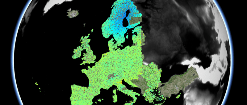
Tag: InSAR monitoring
TRE ALTAMIRA is part of IRIDE
TRE ALTAMIRA is part of IRIDE, Italy’s flagship space program for Earth Observation IRIDE is one of the most important space programs for Earth Observation and a major component of the Italian National Recovery and Resilience Plan (NRRP). The NRRP is part of Next Generation Eu and defines a broad and ambitious package of investments…
Mine stability monitoring
Mine stability monitoring with satellite InSAR One of the main challenges in the mining sector is the monitoring of ground behaviour over large assets, which often experience displacement due to operational activities. Slope instability in particular can be a significant threat to the integrity of mine sites and staff safety. Regular and accurate site stability…
European Ground Motion Service:
An introduction
The first InSAR monitoring service at a continental scale We have come a long way since 1993, when the cover page of Nature magazine hosted a SAR interferogram mapping the ground displacement caused by an earthquake. Almost three decades later, the European Environmental Agency (EEA) initiated the first European Ground Motion Service (EGMS), and with…
Interreg V-A Italia-Svizzera
A cross-border collaboration to improve hazard identification and mitigation efforts In our September 2020 post 'TRE Altamira and GEORESEARCH: The SedInOut Project', we highlighted our involvement in Interreg Europe, a interregional program funded by the European Regional Development Fund (ERDF). By encouraging knowledge and information sharing across regions, Interreg Europe helps local and regional governments…
