
The first InSAR monitoring service at a continental scale
We have come a long way since 1993, when the cover page of Nature magazine hosted a SAR interferogram mapping the ground displacement caused by an earthquake.

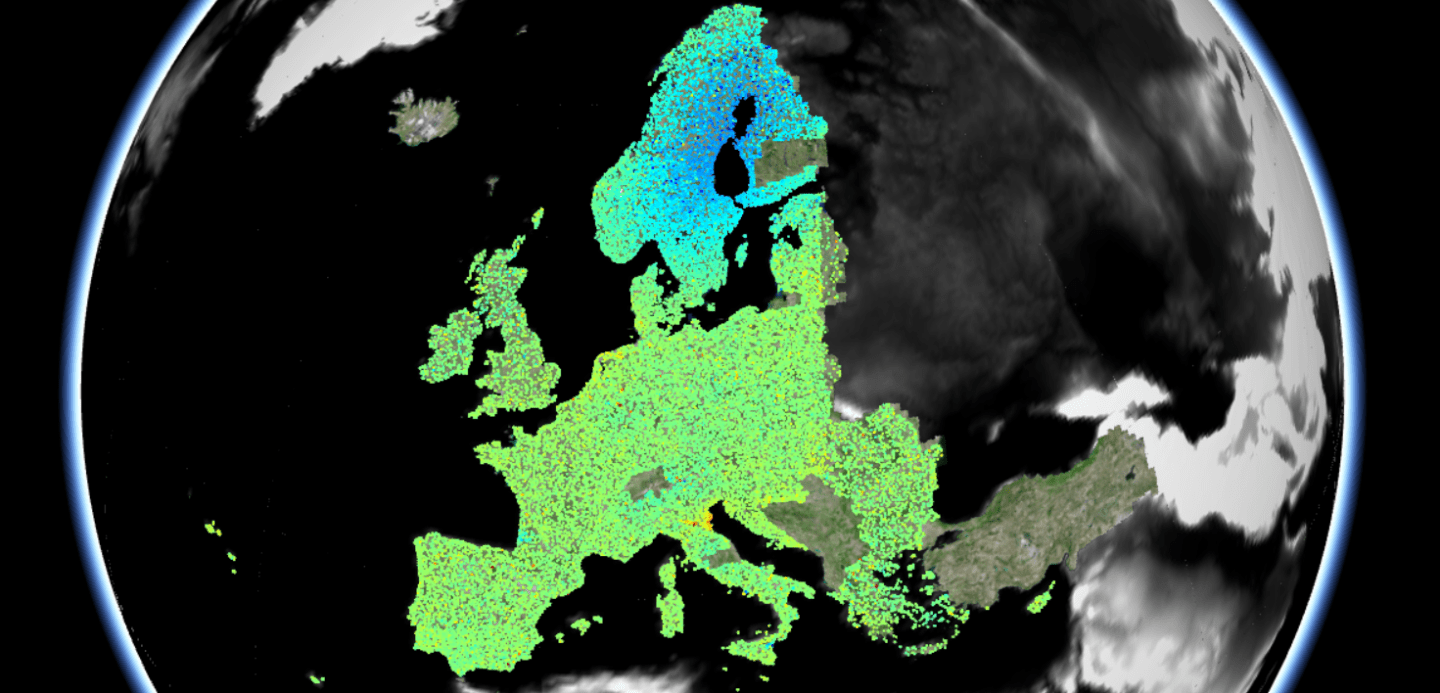
Almost three decades later, the European Environmental Agency (EEA) initiated the first European Ground Motion Service (EGMS), and with it, the start of continental-scale monitoring of European ground deformation, entering a new era for SAR data processing.
EGMS is part of the EU’s Copernicus Land Monitoring Service (CLMS). Based on data from the Sentinel-1 radar satellite constellation, EGMS provides millimeter-scale ground and structural displacement measurements across the entire European continent to better understand and mitigate the risk posed by geological hazards.
InSAR, the radar satellite technology employed for the project, has progressed significantly since its inception, evolving from the ‘two-image’ mapping of ground movement to the ‘whole-archive’ mapping of ground motion. The incredible developments of the technology, along with those in high-performance computing and mass-data processing, have allowed frequent and accurate production of data with results easily accessible via user-friendly web platforms.
A year ago, the EGMS machine started: Petabytes of SAR data have been processed corresponding to nearly 5 million km2 to produce the initial six-year baseline. Since the start, the EGMS consortium has worked ceaselessly to harmonize the results of four different processing chains to deliver the first set of data. The mass-production has been divided between four processing InSAR providers and TRE Altamira’s initial output covers nearly 2 million km2. Annual updates of the initial 2015-2020 baseline dataset will be provided until 2024 in the current contract.
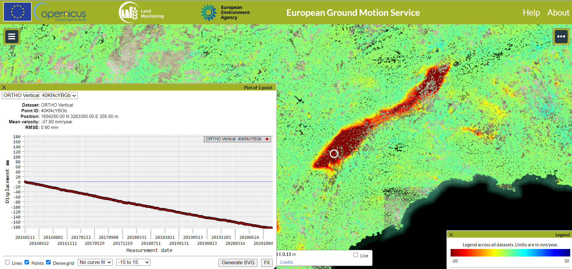
In May 2022, we witnessed the first EGMS release of the Ortho products. These provide mm-scale displacement measurements in vertical and horizontal orientation calibrated to a GNSS model.

The data are available via the Copernicus portal for anyone to freely visualize, interrogate and download.
EGMS offers three levels of product:
- Basic: Line of sight velocity maps in ascending and descending orbits with annotated geolocalisation and quality measures per measurement point;
- Calibrated: Line of sight velocity maps in ascending and descending orbits referenced to a model derived from the time-series data from global navigation satellite systems;
- Ortho: Components of motion (horizontal and vertical) anchored to the reference geodetic model. Ortho products are resampled to a 100 m grid.
Users can investigate ground motion over large areas, such as an entire city or country, down to a single infrastructure. Higher level of details can be achieved using high resolution SAR imagery, often available over many European cities.
The information can be useful to a wide range of applications, and overall will improve our knowledge of Europe’s ground motion phenomena that can be both costly and dangerous. EGMS is an invaluable information source that will also increase awareness of this awesome satellite technology.

TRE Altamira is proud and honored to be part of the ORIGINAL (OpeRatIonal Ground motion INsar ALliance) consortium and work together with e-geos (prime), Norce, and GAF, and to collaborate with the German Aerospace Center (DLR), the Geological Survey of Norway (NGU), the Hungarian Satellite Geodetic Observatory (SGO), the companies Earth Metrics, PPO.labs, and Nhazca.
EGMS is a project funded by the European Environment Agency (EEA), as part of the Copernicus Land Monitoring Service (CLMS). The ORIGINAL Consortium is formed by e-geos, TRE Altamira, Norce, GAFAG, with the collaboration of Nhazca, Earth Metrics, Geological Survey of Norway, PPO.Labs, SGO, and DLR.
For more information visit the European Ground Motion Service or TRE Altamira websites.