
We are dedicated to making satellite SAR (Synthetic Aperture Radar) data a standard information source to monitor surface motion and change
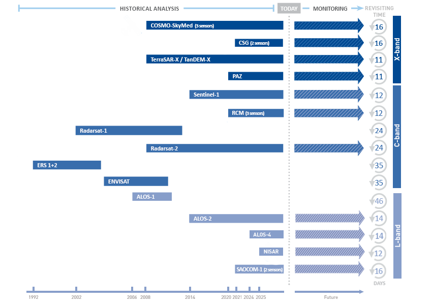
All SAR satellites orbit the Earth on a near-polar orbit at an altitude ranging from 500 to 800 km above the Earth’s surface. The time taken for a satellite to re-pass over the same area is called the ‘revisiting time’. Since the launch of ERS satellites in 1992, numerous satellites have been orbiting the Earth, providing higher resolution images, faster repeat times and data redundancy for many parts of the world.
SAR satellites
Synthetic Aperture Radar (SAR) satellites acquire images of the Earth’s surface by emitting electromagnetic waves and analysing the reflected signals.
All SAR satellites travel from the north pole towards the south pole for half of their trajectory (descending orbit) and from the south towards the north pole for the other half (ascending orbit). As a consequence, the same area of interest is revisited along the two orbits with ascending and descending imageries collected over it through time.


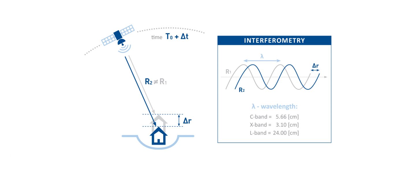
SAR signal
Each SAR image incorporates two fundamental properties: phase and amplitude.
The phase contains information about the sensor-to-target distance that is used in interferometric applications (InSAR or SAR Interferometry) to measure ground surface motion over time. The amplitude is related to the energy of the backscattered signal and it is used in speckle/pixel tracking applications and ground change detection.
No ground equipment is needed. SAR satellites detect targets already existing on the ground (e.g. buildings, linear structures, rocky outcrops, uncultivated lands, debris, etc.) and register their backscattered signals.
Techniques
By exploiting both the phase and amplitude properties of SAR imagery, TRE ALTAMIRA has developed different techniques to extract surface displacement measurements and to detect information about surface characteristics and variations.
| Measure | |||
|---|---|---|---|
| InSAR Displacement Map | SqueeSAR® | Rapid Motion Tracking (RMT) | |
| Range of movement | Displacement > few cm | Displacement rate < few cm/year | Displacement rate > few cm/year |
| Minimum # SAR images | 2 | 15-20 | 10 |
| Max measurement precision | Centimetric | Rate: lower than 1 mm/year Single measure: lower than 5 mm | 1/10 SAR image pixel (from few to tens cm) |
| Spatial resolution | Tens of pixels (tens of metres) | One-point target | 50-100 pixels (hundreds of metres) |
| Movement components | 1D (LOS) 2D (Vertical, East-West) | 1D (LOS) 2D (Vertical and East-West) | 2D (LOS and Azimuth) 3D (Vertical, North-South, East-West) |
| Output | Geotiff raster map, kmz | Set of georeferenced points with displacement Time Series (shapefile or other database) | Sets of georeferenced points with displacement Time Series (shapefile or other database) |
| Applicability | Displacement rate > few cm between two acquisitions Areas not affected by decorrelation or strong atmospheric noise | Displacement rate between mm/year and few cm/year Coherent radar targets over time | Displacement rate > cm/year Areas with a good and persistent reflectivity |
| Detect | |||
|---|---|---|---|
| Interferogram | Amplitude Maps | Change Detection Maps | |
| Range of movement | - | - | - |
| Minimum # SAR images | 2 | 1 | 2 |
| Max measurement precision | - | - | - |
| Spatial resolution | Tens of pixels (tens of metres) | Few pixels (few metres) | Few pixels (few metres) |
| Movement components | - | - | - |
| Output | Geotiff raster map, kmz | Geotiff raster map, kmz | Geotiff raster map, kmz |
| Applicability | Detection of areas affected by surface motion between two acquisitions Areas not affected by decorrelation or strong atmospheric noise | Detection of surface reflectivity characteristics | Detectection of surface reflectivity variations |

Our processing infrastructure
We have an in-house data centre, designed to cope with the high demand for SAR imagery processing and storage.
The architecture consists of a Linux-based parallel processing system, made up of approximately 30 servers and 204 cores for data processing and 20 CPUs for interactive session management. The system has a storage capacity of 350 TByte accessed via a high-performance parallel file system.
Since 2017 we have also increased our processing capabilities by exploiting the potential of Amazon’s AWS cloud service. This new resource can be activated on demand to manage workload peaks and monitoring projects independently of both the number and the geographical dimension of studied areas.