Denmark: ground motion now being monitored using Copernicus satellites and TRE-A technology

InSAR measurements over Denmark

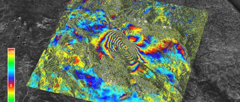
The Danish Agency for Data Supply and Efficiency (SDFE), part of the Danish Ministry of Energy, Utilities and Climate, has appointed TRE ALTAMIRA to process all Sentinel-1 A/B images collected over Denmark, along both ascending and descending orbits of the satellites, using SqueeSAR® technology. This is done as part of SDFE's work towards setting up…

Coastal Subsidence Mapping with InSAR

InSAR study over Hampton Roads

Coastal subsidence mapping with InSAR for sea level rise vulnerability mapping over Hampton Roads. Hampton Roads is located within the southeastern corner of the state of Virginia, USA. This coastal inlet is predominantly urban and has the largest concentration of federal bodies and facilities of any metropolitan area in the world. This area is experiencing…

InSAR nationwide monitoring: the Italian case

InSAR Monitoring over Italy

TRE ALTAMIRA together with E-geos have processed thousands of SAR images to cover the entire Italian territory within the framework of the PST project (Piano Straordinario di Telerilevamento), which went live in 2008, years prior to the launch of Sentinel-1 satellites. The PST results are now presented in the article: “Analysis of surface deformations over…

Can InSAR contribute with new insights into possible earthquake precursors?

Co-seismic interferogram #L'Aquila

This controversial issue is under analysis in a paper co-authored by Fabrizio Novali, R&D manager of TRE ALTAMIRA, now published in Scientific Reports – Nature.   Seismologists at INGV (Istituto Nazionale di Geofisica e Vulcanologica) have analysed ground displacement before and after the L’Aquila earthquake, which struck the central part of Italy in April 2009…

Néuquen Basin: Sentinel-1 ground deformation study

InSAR ground deformation maps #Néuquen-Basin

We are pleased to be featured in the latest issue of Géologues, the French Geological Society magazine. The article “L’interférométrie radar au service de la cartographie et de la surveillance des mouvements du sol. Application à l’étude des déformations dans le bassin de Neuquén (Argentine)” details our InSAR project with the multinational company TOTAL to…