

We have generated new flood maps using SAR images in the framework of the Hydrology Thematic Exploitation Platform (TEP).
The TEP for Hydrology is an ESA Portal providing large scale Earth Observation (EO) products and services customised for hydrological applications. TRE ALTAMIRA has developed an algorithm to obtain hydrological products (water mask, flood maps and statistics) employing SAR images and allowing to combine them with overlapping optical images.

The identification and delimitation of floods from EO data is a need for many hydrological communities and experts as well as Water Authorities. Additionally, there is a need to have an instrument to manage and share all the available information. Because of the high volumes of EO data, the water community needs to have access and process large amount of data in a rapid, flexible and customised way so they can understand better which are the trends and the impacts. The TEP for Hydrology, managed by Terradue, aims at simplifying the access, sharing, visualisation and integration of data.
However, the user community needs not only to monitor floods but also to forecast them. Due to climate change forecasting is now more important than ever before and having good forecast tools is the key concept for the future. These needs are especially critical in those developing countries where data is still scarce. An optimal tool for managing and forecasting different scenarios is the use of comprehensive hydrological models and EO data can feed and improve these models.
TRE ALTAMIRA is the service provider in the Hydrology TEP for:
- Flood Monitoring Service
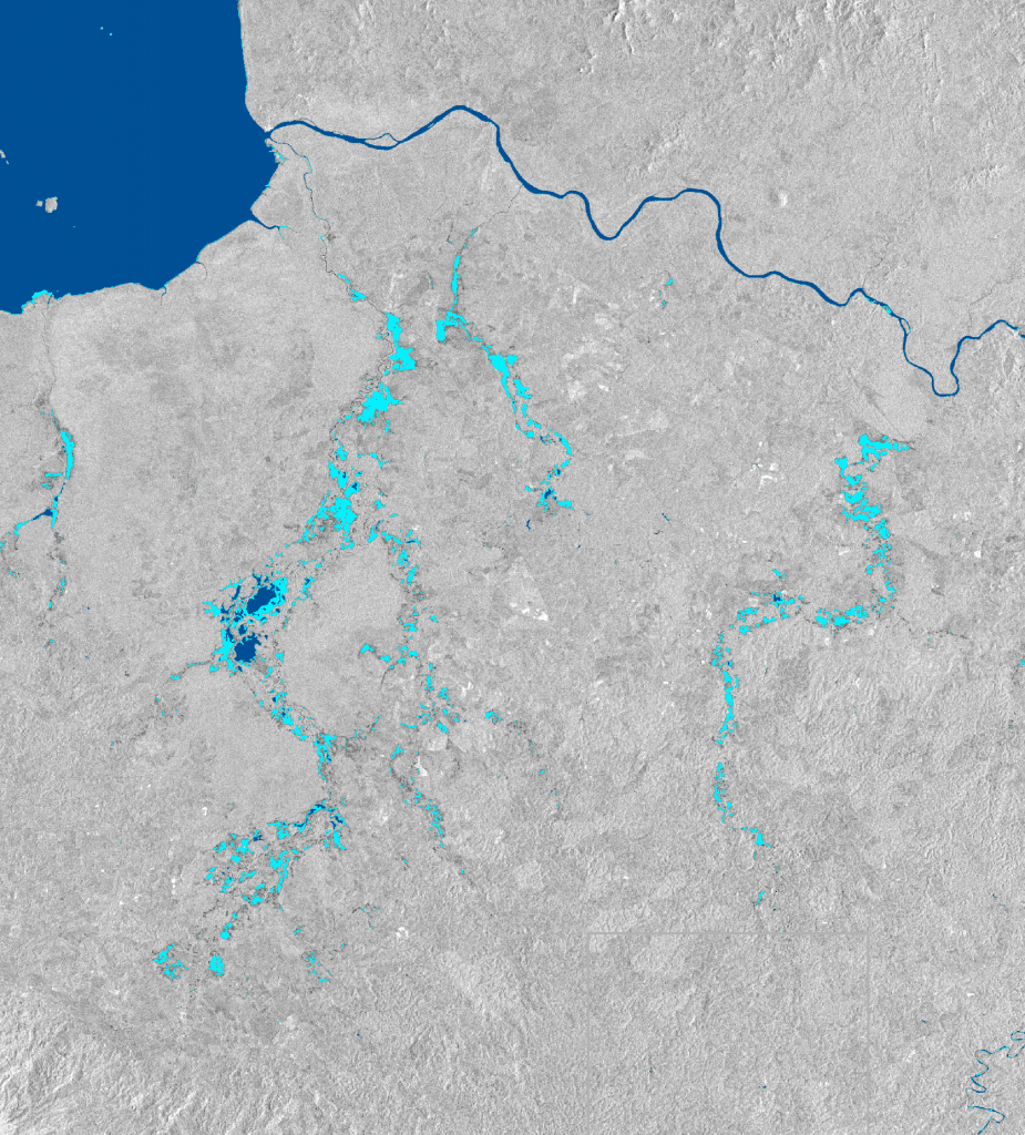
The Flood Monitoring Service developed by TRE ALTAMIRA enables detecting and delineating the extent of the area affected by flooding at high resolution using data from Sentinel-1 and other sensors as well as the possibility of refining the results using Sentinel-2 Optical Data. Additionally, the service includes further analysis to assess the evolution of water extent and floods over time: water and flood frequency maps, maximum floodable area and time series of floods.

- Small Water Body Mapping Service
The Small Water Body Mapping Service developed by TRE ALTAMIRA provides the extent and temporal evolution of permanent and non-permanent water bodies in the form of detailed mapping, Time Series and evolution of water bodies’ surface in time. The service is based on Sentinel 1 SAR acquisitions and ASAR for historical analysis as well as the possibility of results refinement using Sentinel-2 Optical Data.

More than 50 organisations and communities are interested in the Hydrology TEP services. We know that floods and their associated risks are an increasing threat situation in many countries. Climate change and water crises have featured prominently over the last years in the Global Risks Report made by the World Economic Forum.
In this context, reliable information of potential local hazards will prove invaluable to end users in the different applications related to water management such as water resource management, floods monitoring, water quality monitoring, monitoring of water level and water bodies evolution. EO data can play a significant role and the Hydrology TEP provides a real benefit for users working towards a robust SAR-based flood monitoring service capable of working in different conditions such as different seasons and land covers in an adaptive automatic way.