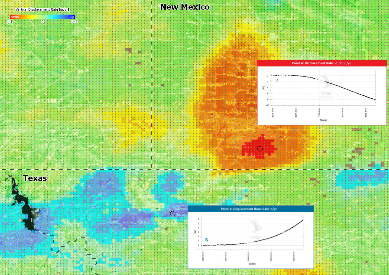
InSAR subscription service for enhancing Permian Basin operations

align=
Historical archives

Displacement data going as far back as 2015 included in any subscription. Characterize past and ongoing ground deformation.

align=
Dense temporal sampling

12-day satellite revisit time results in dense temporal sampling. This can help to identify and characterize non-linear and changing deformation trends.

align=
Full Basin Coverage

Full basin coverage of the Midland, Delaware or both basins.

Monitor and Characterize Pore Pressure Changes in Time and Space

Pore pressure changes have been occurring since the start of production in the Permian Basin. Where net pore pressure reduction is occurring, subsidence can be observed in the resulting InSAR data; conversely where water disposal is high and net pore pressure change is positive, uplift can be observed.

Using the InSAR data available over large or small areas, the magnitude, timing and spatial extents of these pore pressure changes can be better understood, and where required, managed and modified.

Data can be sliced to any time periods to analyze the effects of these activities on different time scales.

Monitor and Identify Well Failures

With an increasing number of production and injection wells in the Permian Basin, ensuring well integrity remains a top priority for operators, regulators and other stakeholders.

InSAR is a proven technology for identifying, and in cases, predicting well failures.

Monitor Infrastructure

Infrastructure such as pipelines or railways are particularly sensitive to differential displacement.
With thousands of these critical pieces of infrastructure throughout the Permian Basin, monitoring and identifying high risk areas is an ongoing activity.

InSAR displacement results can aid operators , regulators and other stakeholders in identifying the pipelines and other infrastructure which have been subjected to the most historical and ongoing displacement.

Quantify Induced Seismic Events

Induced Seismicity is an ongoing phenomenon in the Permian Basin.

InSAR results can be produced following these events to characterize the distribution of associated ground displacement.

Magnitude and spatial extents of surface deformation related to earthquakes can be measured and mapped with InSAR.